 MarineTraffic - Ship Tracking


The worlds #1 ship tracking app!
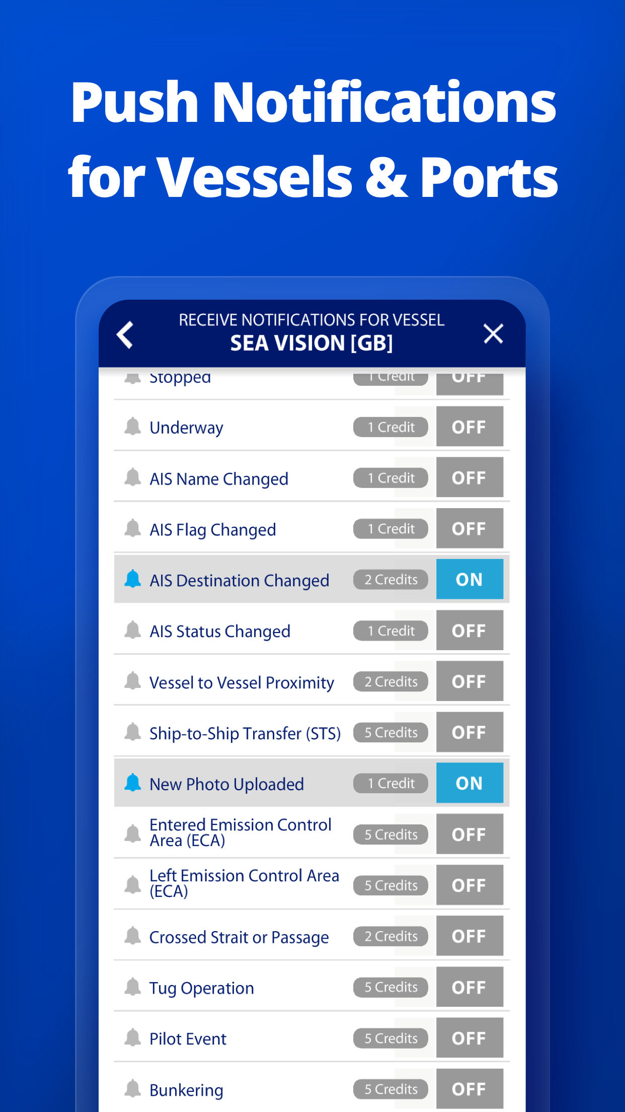
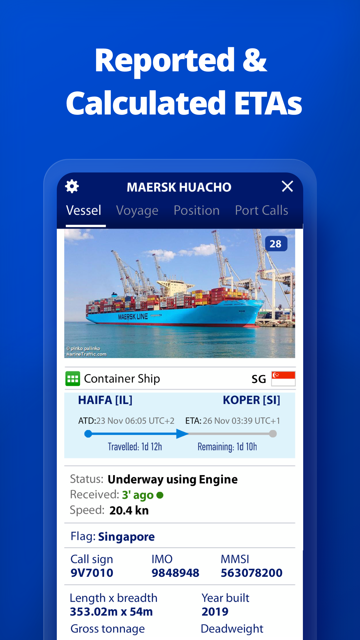
MarineTraffic displays near real-time positions of ships and yachts worldwide. Connected to the largest network of land-based AIS receivers, the app covers most major ports and shipping routes.• View VESSELS ON THE LIVE MAP, search for ships, boats and seaports and see whats near you!• More than 100,000 VESSELS PER DAY report their positions via MarineTraffic AIS• View live wind and 48-hour WIND FORECASTS on the map• ANIMATED PLAYBACK of vessels track• PORT ARRIVALS & DEPARTURES live for over 4,000 ports and marinas, current conditions in ports and estimated time of arrival for the boats & ships.• Manage your list of vessels ("MY FLEET"), shared with all your devices and MarineTraffic.com• Browse 2,5 MILLION PHOTOS of ships, harbours, lighthouses and much more!• Identify and track vessels sailing beyond the range of land-based AIS receiving stations, using satellite tracking, with ACCESS PLUS 24 (in-app purchase)• Identify vessels around you at a glance with the Augmented Reality tool.Just point your devices camera to the horizon and get all the information you need about the vessels in your area: name, flag, speed, distance from you and a lot more.Also, for MarineTraffic paying subscribers:• NAUTICAL CHARTS• ADVANCED WEATHER MAPS• ADVANCED DENSITY MAPS• SAT-AIS DATAJoin the great MarineTraffic community!** If youre only interested in a specific area, please confirm coverage on www.marinetraffic.com before purchasing the app **- Areas of Interest- Enhanced Port calls with filtering- Advanced search for ports- Enhanced advanced search for vessels- Updated density maps- Updated vessel ownership- Smart filters for Advanced Map- Extended view and filtering for Vessels in Port, Arrivals/Departures and Expected Arrivals- Additional map styles- Numerous fixes and improvements
MarineTraffic displays near real-time positions of ships and yachts worldwide. Connected to the largest network of land-based AIS receivers, the app covers most major ports and shipping routes.• View VESSELS ON THE LIVE MAP, search for ships, boats and seaports and see whats near you!• More than 100,000 VESSELS PER DAY report their positions via MarineTraffic AIS• View live wind and 48-hour WIND FORECASTS on the map• ANIMATED PLAYBACK of vessels track• PORT ARRIVALS & DEPARTURES live for over 4,000 ports and marinas, current conditions in ports and estimated time of arrival for the boats & ships.• Manage your list of vessels ("MY FLEET"), shared with all your devices and MarineTraffic.com• Browse 2,5 MILLION PHOTOS of ships, harbours, lighthouses and much more!• Identify and track vessels sailing beyond the range of land-based AIS receiving stations, using satellite tracking, with ACCESS PLUS 24 (in-app purchase)• Identify vessels around you at a glance with the Augmented Reality tool.Just point your devices camera to the horizon and get all the information you need about the vessels in your area: name, flag, speed, distance from you and a lot more.Also, for MarineTraffic paying subscribers:• NAUTICAL CHARTS• ADVANCED WEATHER MAPS• ADVANCED DENSITY MAPS• SAT-AIS DATAJoin the great MarineTraffic community!** If youre only interested in a specific area, please confirm coverage on www.marinetraffic.com before purchasing the app **- Areas of Interest- Enhanced Port calls with filtering- Advanced search for ports- Enhanced advanced search for vessels- Updated density maps- Updated vessel ownership- Smart filters for Advanced Map- Extended view and filtering for Vessels in Port, Arrivals/Departures and Expected Arrivals- Additional map styles- Numerous fixes and improvements